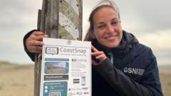

CoastSnap is part of a project called Co-creating Coastal Resilience (CoCor)
By
Agriculture and environment correspondent, BBC News NI
Beachgoers are being invited to become citizen scientists to help track how our coastline is changing.
Armed with nothing more than a smartphone, visitors to Tyrella Beach in County Down can now take part in a global project by snapping a photo through a fixed frame and logged via a website.
Each picture becomes part of a growing record that scientists will use to monitor how the beach shifts over time, helping them understand the effects of coastal erosion, rising sea levels and climate change.
Open days will be held to show people how to get involved.
As a geomorphologist with Geological Survey Northern Ireland, Melanie Biausque studies how coastlines change over time.
She is leading the project in Northern Ireland and said people who regularly visit the beach have the power to transform scientists' understanding of how it is changing.
"We're trying to understand how the coastline changes now and how it will evolve in the future, what can we do now to protect it so it's not too impacted by the changes that are going to happen in the environment."

CoastSnap cradle on Tyrella beach
Why Tyrella?
The shifting sands at Tyrella beach are home to the first CoastSnap photo spot in Northern Ireland.
CoastSnap, which began in Australia, is part of a project called CoCor - Co-creating Coastal Resilience.
Tyrella was chosen because of the work local volunteers have already carried out to restore its sand dunes.
Biausque first learned about their work after seeing a presentation to Newry, Mourne and Down council, where volunteers spoke of how they had collected seeds to plant new marram grass, and installed fencing and signage to protect the seedlings.
"When I heard that, I realised that I had never had any idea that was happening - and I really wanted to put that on the map and to say, things are happening," she said.
"But one thing that we don't do is to see how that evolves."

The photos will help scientists analyse how and why material is deposited in certain olacea and what effect that has on the coast
How is the coastline changing?
Coasts are designed to move - waves, tides, currents and wind are always shifting sand around, while dunes grow and erode naturally over time.
However, Biausque and other scientists are preparing for "big" changes, in the form of sea level rise and more frequent storms due to the effects of climate change.
"If we want to understand how it's going to happen and what's going to happen on the coast, we need to understand what is happening now and how it works."
That is where CoastSnap comes in.
By comparing multiple photos taken from exactly the same position over months and years, researchers can build up a detailed picture of how the coastline responds to different weather conditions and seasons.
The Northern Ireland branch of the project is funded by the Department for the Economy, with more sites across soon to be equipped with the photo cradle and signs to explain how to take part in the project.
'Easy-peasy'
Taking part is simple - the only equipment needed is your phone.
Just one specific part of the coastline will be photographed, so that the team has many pictures of one spot that can form a database of evidence to be studied.
A steel cradle, designed to hold your phone horizontally, has been placed on a fence post.
It holds your phone in exactly the right position, ensuring every photo is taken from the same angle.
An opening in it frames the specific area that the team are interested in - the upper part of the beach where the volunteers carried out their work.
After taking the photo, visitors simply scan the QR code on the sign below and upload it to the CoastSnap website.

Signs and protective fencing are in place to try to give the new grass seedlings the best chance
Biausque said the process is entirely anonymous.
"You don't have to leave your name or anything, unless you want to."
The project will run throughout the seasons and there are options on the page to record what else you notice.
"If you're coming in the winter and you can see coastal erosion or you can see vegetation change, you can click on those and you can add comments - though you don't have to," she added.
While people like Biausque cannot visit Tyrella every day, regular visitors can help the scientists answer their questions by sending photos.
"Why do we have algae standing here? Why sometimes you can see the vegetation progressing? Why do you come in the winter and the beach is so different?
"All of this is the interaction between the sand or the sediment and the waves, the currents, the tides, and at the minute we know that all of those processes are going to change in the future.
"But to understand how we can live with it and adapt around that, we need to understand better how it works today. So that's why we need to collect."